Monday, February 28, 2011

"Anjar"

 
Posted by Picasa


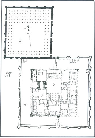
"Anjar, the fortified 'new town' founded during the reign of the Caliph al-Walid (AD 705-15), but which was destroyed only a few decades later (After Salame-Sarkis);

1. great palace;

2. mosque;

3. small palace;

4. "hamam" (public baths);

5. housing (excavatated);

6. central junction of maind shop-lined roads with a Roman-style monumental tetrastyle;

7. North Gate;

8. East Gate;

9. South Gate;

10. West Gate;

11. One of twelve pairs of stairs onto the fortified wall:

12. One of four hollow corner towers (the other 36 towers, including those flanking the gates are solid).

Reference:

D. Nicolle, "Saracen Strongholds AD 630-1050," Fortress 76, (Osprey Pub.-2008), P. 8-9

Wednesday, February 23, 2011

Cross-section and plan of the Theodosian Walls of Constantinople

 
Posted by Picasa


This plate shows a complete cross-section and plan of a typical stretch of the Theodosian Walls. The section shows the different layers of defense. On the plan, are the different shapes of the towers.

From Left to Right:

--Moat ( 61 ft. wide, and more that 20 ft. deep);

--Moat Walls (6 ft. 6 in. high);

--Parateichion (terrace between the outer wall and the moat wall, 61 ft. wide, and it's main purpose was to extend the distance between the besiegers and the besieged);

--The Outer Wall (The outer wall is from 2 ft to 6 ft 6 in. thick, and rises 27 ft, 6 in. above the Parateichion);

--Peribolos (terrace between the Inner and Outer Walls which accommodated the soldiers who defended the Outer Wall. It was 50 to 64 ft. wide.);

--The Inner Wall (96 towers were 57 to 60 ft. high, and spaced between 175 ft. to 181 ft. apart. It rises 40 ft. above the city level and varies in thickness from 15 ft. 6 in. near the base to 13 ft. 6 in. at the top.);

The Theodosian Walls were constructed using both stone and brick. In the detail of the wall showing the cross-section of the wall, both materials can be seen. Brick was used more sparingly than stone.

Reference:

Stephan Turnbull, "The Walls of Constantinople AD 324--1453," Fortress 25, Osprey Pub., London, 2004, pp.10-13.

Kafr Lam Fortress

 
Posted by Picasa


This fort rests on the Mediterranean coast, South of Haifa. It is an early Islamic period fort, but strengthened in the ninth or tenth century AD (After H. Barbe et al.).

1. Pre-Islamic Romano-Byzantine structures;

2. Crusader chapel with apse cut into the wall of the fort;

3. Later Islamic structures from the Ottoman Period.

Reference:

David Nicolle, "Saracen Strongholds AD 630 - 1050, The Middle East and Central Asia," Fortress 76, Osprey Pub., London, 2008, pp 29.

Mosque / Fortified Headquarters, Kufa, Iraq

 
Posted by Picasa


The fortified Dar al-Imara administrative headquarters was founded in AD 638 , but was rebuilt in AD 670 by the governor of Basra (After G. Macheil).

1. Mosque;

2. Central Courtyard;

3. Fortified Inner Enclosure;

4. Outer Fortifications.

Reference:

David Nicolle, "Saracen Strongholds AD630 -- 1050, The Middle East and Central Asia," Fortress 76, Osprey Pub., London, 2008, pp.8-9

Tuesday, February 22, 2011

Harran Citadel

 
Posted by Picasa


Ancient structures, including a Sabaean Temple which remained in use throughout the early Islamic period are shown in black. Early Islamic fortifications , including the East gate with its carved decorations, are shown in dark grey. The early thirteenth century citadel is shown in white with dark lines (After Hanisch and Faucherre).

Reference:

Davis Nicolle, "Saracen Strongholds, The Central and Eastern Islamic Lands," Fortress 87, Osprey Pub., London, 2009, pp. 5.

Lashkari Bazar

 
Posted by Picasa


This is a diagram (floor plan) of the late eleventh to twelfth century fortified palace built for the Ghaznawid rulers of Afghanistan and northern India. Part of the northwestern corner of the palace has been eroded by the River Helmand and there was an irrigation canal in the narrow space between the palace and the river (see the green line):

1. Great northeastern tower;

2. Audience hall decorated with wall-paintings and with a small pool fed by the East-West channel (After Schlumberger and Ettinghausen).


Reference:

D. Nicolle, "Saracen Strongholds 1100-1500," Fortress 87, Osprey Pub.-2009), P. 5

Side,Top, and Section Views of the trireme "Olympus"

 
Posted by Picasa


The ship views shown here are scale drawings. The 170 rowers were arranged in three files on each side: 31 in the top bank and 27 in each of the two lower banks. The six files are arranged in a "V" shape, with the lowest bank farthest inboard and the top one farthest outboard. The seats of the rowers in the top and bottom files were angled a few degrees inboard, so that all the oar tips were evenly spaced.

Reference:

"Scientific American," April, 1989

http:www.usu.edu/markdamen/1320Hist%26civ/slides/02herod/trireme.jpg

Greek Trireme -- Modern Day Construction

 
Posted by Picasa


This is a bow on photograph of the vessel under sail with the oars brought inboard. Note the two eyes of the ship just above her Bronze Ram.

Reference:

http://library.thinkquest.org/06aug/00336/images/trireme.1.jpg

Picture of an Ancient Greek Trireme

 
Posted by Picasa


Reference:

http://philo-lettres.pagesperso-orange.fr/trireme.jpg

Greek Trireme

 
Posted by Picasa


This is a view from the stern of the vessel. Note the double lateral rudders and the curvature of the hull into a upturned stern.

Reference:

http://www.jimpryor.net/teaching/courses/intro/notes/images/trireme.jpg

Greek Trireme

 
Posted by Picasa


Reference:

http://upload.wikimediaorg/wikipedia/commons/thumb/6/6d/Trireme_1.jpg/755px-Trireme_1.jpg

Monday, February 21, 2011

Aleppo Citadel

 
Posted by Picasa


Vertical Section through the entrance complex of Aleppo Citadel. The domed upper chambers above the thirteenth century gate were added in the late Mamluk period. (After Kennedy and Tabaa)


Reference:

David Nicolle, "Saracen Strongholds - 1100 -- 1500, The Central and Eastern Islamic Lands," Fortress 87, Osprey Pub., London, 2009, pp. 5.

Cairo Citadel

 
Posted by Picasa


The northeastern Burj al-Ramiah tower of the Cairo Citadel with Saladin's late twelveth century tower in black, and al-'Adil's thirteenth century 'great tower' in grey (After Creswell).

Reference:

David Nicolle, "Saracen Strongholds- 1100--1500, The Central and Eastern Islamic Lands," Fortress 87, Osprey Pub., London, 2009, pp. 5.

Aleppo Citadel -- Ground Floor Plan -- Entrance Complex

 
Posted by Picasa


(After Kennedy and Tabaa)

Much remains of Aleppo's medieval defenses, most notably the citadel. Nur al-Din (1147 -74) added an outwork or "fasil" to the city's existing curtain wall to join the already fortified but separate southeast suburb Qal'at al-Sharif to the main city defenses. Nur Al-Din's work also included a second circuit wall or "sur" in advance of the main city wall.
(Allen 1996)

Reference:

David Nicolle, "Saracen Strongholds, 1100 - 1500, The Central and Eastern Islamic Lands," Fortress 87, Osprey Pub., London, 2009

Fortress of Anavarza (Arabic: Ayn Zarba)

 
Posted by Picasa


This fortress was constructed in the frontier zone between Islamic and Byzantine Empires. It was strongly refortified by the 'Abbasid Caliph Harun al-Rashid in AD 796 and again by the Hamdanid Ruler of Aleppo in the tenth century AD.

1. largely abandoned pre-Islamic lower city;

2. lower castle surrounded by fortifications on northern and eastern sides, and by sheer cliffs on the southern and western sides;

3. surviving gate of lower castle, probably 'Abbasid late eighth century AD;

4. walls and towers largely rebuilt in the twelfth and thirteenth centuries AD;

5. first entrance complex to upper citadel, strengthened during Armenian period;

6. second entrance complex, probably Islamic, eighth to tenth centuries AD;

7. upper citadel


Reference:

D. Nicolle, "Saracen Strongholds AD 630-1050," Fortress 76, (Osprey Pub.-2008), P. 29

Citadel of Amman, Jordan

 
Posted by Picasa


This Citadel was refortified during the late Umayyad period c. AD 725 -- 745, and restored in the ninth - tenth century following earthquake damage. The palace complex probably dates from the same period as the Umayyad fortifications (after A. Northedge).

1. inner courtyard leading to the throne room;

2. outer courtyard;

3. "hamam" (public baths) and cistern area;

4. well;

5. "rahba," (public square);

6. upper citadel;

7. lower citadel;

8. ruined Roman Temple;

9. main gate.

Reference:

David Nicolle, "Saracen Strongholds AD 630 -- 1050, The Middle East and Central Asia," Fortress 76, Osprey Pub. London, 2008.

Umayyad "desert palaces" in the Fertile Cresent

 
Posted by Picasa


A. -- C. Development of Qasr Hallabat in Jordan, (after I. Arce);

A.--Late Roman "Limes Arabicus quadriburgium", fourth and fifth centuries AD;

B.--Ghassanid Arab "pretorium," sixth century following the earthquake of AD551;

C.--Umayyad palace and mosque, seventh and eighth centuries AD destroyed by an earthquake in AD 748 / 9;

1.--Original Roman second century AD fort enclosed by later Roman Fortifications;

2.--enlargement of Roman Fort in the second or third century AD;

3.--cistern;

4.--Umayyad palace;

5.--Umayyad mosque outside the fortifications.

Reference:

David Nicolle. "Saracen Strongholds AD 630 -- 1050, The Middle East and Central Asia," Fortress76, Osprey Pub., London, 2008

Early Islamic Qasr Atshan in Iraq

 
Posted by Picasa


D. -- E. Early Islamic Qasr Atshan in Iraq probably the first half of the eighth century AD:

D.-- Plan;

E.--facade of the Iwan, vaulted reception hall;

1. Gate;

2. Courtyard;

3. Iwan;

4. Inner chambers.

Reference:

David Nicolle, "Saracen Strongholds, AD 630 --1050, The Middle East and Central Asia," Fortress 76, Osprey Pub., London, 2008.

Friday, February 18, 2011

Cairo Citadel

 
Posted by Picasa


This drawing shows the fortifications and main internal structures in the late 12th to 14th centuries. Saladin's late 12th century fortifications are in black. Early 13th century "great towers" in grey:

1. Upper Enclosure;

2. Lower Enclosure;

3. Bir Yusef well;

4. Mosque of al-Nasir Muhammad;

5. Great Iwan "reception hall of al-Nasir Muhammad";

6. Aqueduct from the Nile;

7. 'Maydon' Training Ground;

8. 'Toblakhanah';

9. Burj al-Ramlah tower (After Cresswell, Behrens, and Rabbat).

The Citadel of Cairo has remained a main fortress and military center into the modern times. Consequently most of Sultan al-Adil's buildings within the fortifications were replaced by newer structures during the Mameluke sultanate; then several Mameluke buildings were replaced by those of the Ottoman Turks, most of which were replaced by Muhammad Ali's 19th century reconstruction program. Even today modern additions to the citadel, such as a theatre, are useful for the people of Cairo, but have damaged certain historical remains.

Reference:

David Nicole, "Saracen Strongholds 1100-1500," Fortress 87, Osprey Pub. London, 2009, pp. 5, 56-57.

Osberg Ship Plan

 
Posted by Picasa


Side and Top view of the reconstructed Osberg Ship Plan. Osberg is the oldest Viking ship found, and it and other like it were probably used in the the early Viking raids around the year AD800. It was probably a royal yacht for inshore use. The design is less seaworthy than younger ships. It is supposed by sailing men that the vessel could have made it to Britain during the Summer, but the hull and sailing gear were not nearly as sophisticated as the later ships.

The Osberg ship has oar holes for thirty oars, so we know that this propulsion method was in use some of the time.

Reference:

W. W. Fitzhugh (ed.), "Vikings, the North Atlantic Saga," (2000)

Thursday, February 17, 2011

Twin Citadels, at Uzgen in Kyrgyztan

 
Posted by Picasa


Uzgend,Kyrgyztan is the capitol of the Fargana valley under the Quakhanids, AD 11th century. The sites today at Uzgend: 10th-century minaret and later mausoleums on what was one of the fortified hills of the early medieval Islamic frontier city.

Reference:

David Nicolle, "Saracen Strongholds AD 630 - 1050." Fortress 76, Osprey Pub., London, 2008. pp. 29.

Damascus Citadel

 
Posted by Picasa


The surviving late 11th - to late 12th century fortress is shown in black lines '////,' those existing only as foundations and the presumed line of missing parts are shown in dark grey '........'. The 13th century Ayyubid and Mamluk citadel, which surrounds the inner citadel, is shown in white outlined in black lines:

!. Bab al-Hadid 'Iron Gate;'

2. Northern gate of a later citadel;

3. Underground Nahr al-Qulayt canal, entering from the West and leaving in the South (After Hanisch)

Reference:

David Nicolle, "Saracen Strongholds, 1100 - 1500," Fortress 87, Osprey Pub., London, 2009, pp. 5.

Sunday, February 13, 2011

Reconstruction of the Ottoman and Venetian Fortress at Butrint (after Karaiska)

 
Posted by Picasa


During their occupation of Albania in the 15th-16th centuries, the Venetians had constructed a two storey artillery tower with loopholes for cannon at the southwestern corner of an existing 15th century triangular fort. When the Ottomans recaptured the fortress, they quickly installed two further round towers for artillery, in the Turkish style, which had two levels, wooden floors, and four embrasures for smaller cannon at the first floor level.

1. Ottoman (probable) 15th century fortified enclosure;

2. Venetian Artillery tower southwestern corner (square);

3. & 4. Ottoman round towers;

5. Ottoman internal buildings;

6. Venetian outer enclosure;

Reference:-

David Nicolle, "Ottoman Fortifications, 1300 to 1710," Fortress 95, Osprey Pub., London, U.K., pp 14, 28-29.

Ottoman Fortress a Bashtov (after Karaiska)

 
Posted by Picasa


Most of the construction work done in the 15th and 16th centuries in Albania was military construction because of the warlike actions in that land. One such fortification was the unit built near Bashtov. This fort was a relatively simple design as it was intended to stand on flat ground. The dimensions of the design were approx. 60 x 90 meters, with curtain walls nine meters in height. There were originally seven towers, one at each corner and one in each of three walls. When the fourth wall was destroyed in a later flood the wall was rebuilt and then included the eighth tower. Each of the corner towers were five stories in height and the side wall towers three stories in height. All towers had wooden floors and wooden roofs, and each tower had embrasures for artillery at the ground level. The interior of the curtain walls had false arches and a double row of loopholes. The false arches supported a walkway which gave access to each of the towers. This was never a very important fortress for the Ottomans.

1. Original Ottoman Fort;

2. Western wall destroyed in a river flood and rebuilt;

3. "musalah" (prayer room) above entrance in the main northwestern gate tower.

Reference:

David Nicolle, "Ottoman Fortifications, 1300 to 1710," Fortress 95, Osprey Pub., London, UK, pp 13-14

Friday, February 11, 2011

Vittangi Boat

 
Posted by Picasa


Vittangi Boat -

Viking ship construction continues today in Scandinavia including production of Viking replicas, small homemade utility vessels, and vessels used by the native Saami such as the one shown above from Vittangi in Northern Sweden. Perhaps someday it will be shown that the design of Viking ships did not originate in the southern Baltic and Europe, but rather from boatbuilding traditions of the northern boreal forests which also survive today.

Reference:--

W.W. Fitzhugh and E. I Ward (eds.), "Vikings: The North Atlantic Saga," Nordic Council of Ministers, Smithsonian Institute, New York, 2000